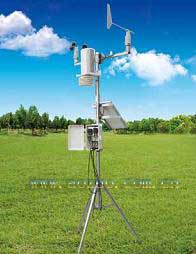
AZ-M0301 ground standard meteorological elements observation system
introduction
Because the meteorological elements in the near-ground layer have uneven spatial distribution and pulsation that changes with time, the surface meteorological observation records must be representative, accurate, and comparable. Ground meteorological observations must fully meet the representative requirements of observation records when selecting the site and instrument performance and determining the installation location of the instrument. Observation records should truly reflect the actual weather conditions. Carry out various data comparisons, so that the regional distribution characteristics and the characteristics of changes with time of meteorological elements can be expressed separately.
At present, there are mainly two types of ground standard meteorological element observation systems in China, one type is the traditional observation system. This type of system generally has a long service life, and the accuracy of the sensors used has not reached the needs of modern observations. It has a single function, poor performance and durability. After data collection, it is urgently needed to be updated through wireless data transmission and post-processing, and online display. The overall performance of foreign systems is superior but the cost is high, which is different from the specific requirements of domestic meteorological observations.
2 Observation system design
2.1 Objective
AZ-M0301 ground standard meteorological elements observation system adopts the latest recorder and meteorological sensors, which can automatically collect air temperature, air humidity, wind speed, wind direction, rainfall, solar radiation, ultraviolet radiation, air pressure, soil temperature, soil moisture, water level, Parameters such as water quality. Rainfall spectrum can be used to analyze raindrop shape, distribution, rainfall intensity, total amount, visibility and other property parameters. It made a qualitative leap in rainfall analysis.
The data collection conforms to the national meteorological business regulations. The system uses solar power supply, no additional power supply device is needed in the field, and the internal battery guarantees the power supply capacity for 20 consecutive cloudy days. The recorder automatically collects and stores records (stored every hour and can store 6 months of data). The working environment temperature range can reach -40 ~ + 50 ℃. The system communicates wirelessly via GPRS. The data is aggregated to the central server for unified processing, storage and real-time display. Users can access from anywhere via the Internet to view ecological environment data at any time.
The system allows users to set up various alarm conditions, and over-limit data can be sent to users via email or SMS. Data reports can be sent to users via email, or regularly sent to other data analysis or expert systems.
2.2 Observation field selection
The observation field should be located at a place that can better reflect the characteristics of meteorological elements in a larger area of ​​the area, to avoid the influence of local terrain; the observation field must be open and flat, and should not be located on steep slopes, depressions or near roads, industrial mines, chimneys, tall The place of the building; the observation field should be located in the upwind direction of the most wind direction, the distance between the edge and the surrounding isolated obstacles is more than 3 times the height of the obstacle; the distance from the row of obstacles should be more than 10 times its height; The maximum water level of large water bodies should be greater than 100 m. No tall pole plants can be planted within 10 m around the observation field.
For areas with heavy rainfall in winter, the area of ​​the observation field is 25m × 25m; for areas with little snowfall or in the south, the area of ​​the observation field should be 15m (east-west) × 25m (north-south direction); where snow does not occur, the area should be 15m × 15m.
The lightning protection of the observation field must comply with the requirements of the "Meteorological Station (Station) Lightning Protection Technical Specifications" (QX4-2000).
Under the premise of meeting the installation requirements of the instrument, the underlying surface should be kept as natural as possible.
2.3 Observation field layout
The wind speed sensor and the wind direction sensor have special installation crossbars, and a circuit for controlling the heating of the sensor is provided, and the circuit is installed in a special junction box. The axis of the transmission shaft should be vertical to the ground, the horizontal bar should point to the north and south, the wind direction sensor should be installed on the north side, and the wind speed sensor should be installed on the south side.
The cross bar of the temperature and humidity sensor is installed on the main wind pole of the automatic weather station, and the placing direction of the cross bar is perpendicular to the down direction of the main wind pole, which is generally placed in the north-south direction. Temperature and humidity sensors and radiation shields are installed on the crossbar.
The weather phenomenon observation system can be used as an atmospheric precipitation measuring instrument at the same time, it can be operated independently, or it can be used as a sensor to connect to the digital channel of a conventional weather station data collector. The sensor is installed on the pole bracket, the pole diameter is 48 ~ 102mm. The pole should be a conductor, connected to earth potential (ground). It can be connected to the ground with a cable with a minimum diameter of 6 mm2. The diameter of the pole should be larger, and the welded pillar is fixed on a concrete underlay surface, and the sensor vibrates.
The distance between the weather phenomenon observation system and the nearby obstacles should be at least 4 times the height of the obstacles. If it is not feasible, at least maintain an azimuth of <45 ° with the surrounding plants, buildings, etc. The sensor should be installed on top of the rod. It is recommended to measure the height at least 1m, or 1.5 ~ 2m in the snow. The distance to other objects should be greater than 2m. First fix the sensor, pay attention to the shading effect of the pole, and fix the sensor at the highest part of the pole, in the south direction. Connect the sensor to the host and then to the power supply.
2.4 Data collection
Data sampling is done in the data collector, and the sampling sequence is air temperature, humidity, precipitation, wind direction, wind speed, air pressure, ground temperature, radiation, and evaporation. The sampling rate of air temperature, humidity and air pressure is 6 times per minute, one maximum value and minimum value are removed, and the remaining 4 sampling values ​​are averaged; the average value of 1 min is the instantaneous value. The sampling rate of precipitation and evaporation is once per minute.
2.5 Observation indicators
Weather phenomena (precipitation type), air temperature and humidity, wind direction, air pressure, total radiation, ultraviolet radiation
Wind speed: The sampling rate is 1 second, there are instantaneous wind speed, 2 minute wind speed and 10 minute wind (in accordance with the national meteorological monitoring specification), the whole point wind speed includes the whole point instantaneous, hour extreme value and extreme value occurrence time
Soil temperature: whole-point soil temperature, maximum soil temperature (within hours), maximum soil temperature appearance time, minimum soil temperature (within hours), minimum soil temperature appearance time
Soil moisture: whole-point soil moisture, maximum soil moisture (within hours), maximum soil moisture appearance time, minimum soil humidity (within hours), minimum soil moisture appearance time
Rainfall: Raindrop size range, particle velocity, rainfall intensity, rainfall, visibility, rainfall type
2.6 Composition of observation system
The observation system consists of field measurement points and data collection units. Recorders and sensors located in the field can automatically collect air temperature, air humidity, wind speed, wind direction, rainfall, solar radiation, ultraviolet radiation, air pressure, soil temperature, soil moisture and other parameters . It can also measure parameters such as water level and water quality.
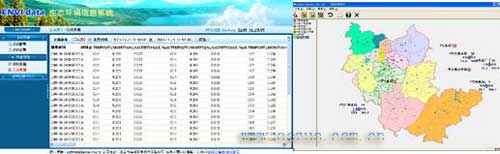
Data receiving unit-ENVIdata server software can simultaneously connect 1000 field stations through GPRS wireless network, receive real-time data, the received data is stored in the server database, and can display various data. As long as users can access the Internet, they can log in to the ENVIdata eco-environmental information system through their username and password.
3 data processing
3.1 Data record and result display
You can log in to the ENVIdata eco-environmental information system by user name and password. After entering the system, users can view real data and historical data, as well as the configuration of the system. Multi-site users can display the status of each site on the map.
Users can also send the data to a large screen to facilitate the public to view the ecological environment of cities and tourist attractions.
Silicone Beauty & Hair Salon Tool
Silicone Beauty & Hair Salon Tool,Facial Mask Mixing Bowl,Silicone Hair Dye Cap,Scalp Massager
DONGGUAN BILLION GOODTOP INDUSTRIAL CO., LTD , https://www.bgoodtop.com