The 2018 World Cup Unified Examination Paper is out, how many points do you have?
Since the start of the 2018 World Cup in Russia, there have been ups and downs and oolongs. Many championships have missed the "starter". The game conditions are confusing and unpredictable. This may be the charm of football.
In this carnival feast of world fans, in the face of overwhelming information bombing, are the fake fans also dominated? Here is a "2018 World Cup Unified Examination Questions", let's see how many points you can get?
1. (Fill in the blank, 5 points) When reading the Russian topographic map, what are the characteristics of Russian topography?
2. (fill in the blank, 10 points) What are the topographical names represented by port B and mountain D in the Russian topographic map?
3. (Short answer question, 20 points) Most of the world ’s rivers and downstream plains are important agricultural areas, but there are almost no farmland in the lower reaches of the three major rivers in Russia ’s Asia. Why?
4. (fill in the blanks, 10 points) Russia is the only country that crosses the two continents of Europe and Asia and the eastern and western hemispheres. What is the European railway network in Russia? As the center, present? Distribution
5. (Multiple choice questions, 10 points) FIFA announced that the 2022 Qatar World Cup will be held from November to December, the final day is December 18, the Northern Hemisphere finally ushered in the first World Cup held in winter . What is the correct description about Qatar?
A. Located near the Tropic of Cancer
B. belongs to tropical desert climate
C. Located along the Persian Gulf
D. Important oil producing countries in the world
Reference answers: 1. East high west low 2. Murmansk; Ural Mountains 3. Russia ’s three Asian rivers in the lower reaches of Asia have higher dimensions, cold climate and insufficient heat, which is not conducive to the growth of crops. 4. Moscow Radial 5. ABC
To tell the truth, it is not uncommon for the World Cup to break into the middle exam papers as a hot topic. Recently, in 2018, the provincial entrance examinations of various provinces and cities across the country opened one after another, and the World Cup figure appeared on the real test papers disclosed in Shanghai, Chengdu, and Shandong. Especially in the subject of geography, maps and topography, weather and climate, countries and regions, these knowledge points can be combined with the World Cup to form novel examination questions. For example, Russia's topography, weather and climate, energy resources, industrial distribution, etc., even if it does not appear on the test paper, it must be repeatedly mentioned in the simulation questions of the middle school entrance examinations in various places.
Among them, maps and topography have always been the teaching difficulties of junior middle school geography. In traditional teaching methods, students rely on repeated identification and rote learning to learn relevant knowledge points, but there are often difficulties in understanding and using subject knowledge flexibly. There are three "artifacts" in the overall solution for digital geography-specific classrooms launched by China Education Qixing, which can perfectly solve the teaching problems of maps and terrain.
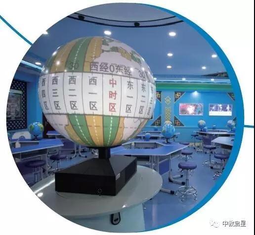
Digital Planet System
The digital planet system is one of the digital educational equipments in the information age, and it is also the first single digital teaching instrument to realize three-dimensional dynamic display in China. It uses an internationally advanced 3D image processing platform, combined with precision optical technology, to instantly display multimedia resources such as pictures, videos, animations, etc. on a digital spherical projection screen. It dynamically reproduces the phenomena and processes of natural and social sciences in a three-dimensional manner. Applied to multi-disciplinary teaching of science, geography, history, etc. in primary and secondary schools and popular science education, to meet the diversified and personalized needs of education within and outside the school, to promote the update of teachers 'teaching concepts, methods and methods, to stimulate students' interest in learning, and to promote changes in learning methods .
Interactive map teaching system
Interactive map teaching system is a digital modern educational equipment product specially designed for modern information geography classroom. This system is designed and produced to highlight the prominent position and function of the map in the geography classroom teaching. It combines the digital thematic map with the teaching courseware. Through ultra-wide screen projection technology, integrated touch, infrared technology and multi-screen linkage technology The limitations and shortcomings of traditional classrooms in the way of regional geographic presentation.
Geography layer learning box
The map layer learning box is suitable for middle school geography teaching. According to the basic principles of the integrity and regionality of the geographical environment, the modern geographical analysis method of layer overlay is used to help students explore the internal connections between the various elements of geography and shape the geography of students. A new carrier of thinking ability.
Based on the "Digital Planet System" digital geography special classroom solution, with the "Digital Planet System" as the core, following the Ministry of Education's "Special Classroom Construction Standards for Middle School Geography", equipped with a regular teaching type interactive map teaching system geographic version, voice stereo terrain Figure; Astronomy Practice Course Resource Pack; Inquiry Geography AR Sand Table; Virtual Simulation Holography Teaching System; Geography Interactive Tool for Experimental Activities, Geography Comprehensive Practice Set, Map Layer Learning Box; Innovation Application Ring Screen, geographic film teaching system 3S series of teaching software and hardware, naked-eye 3D teaching system, geographic learning 3D printing course package; and supplemented by teaching general equipment and environment creation. It can present the knowledge in the geography textbooks more intuitively, vividly and in all directions, which is conducive to the development of teachers 'teaching activities and the improvement of students' learning efficiency.

Dog Bowl,Dog Water Bowl,Slow Eating Dog Bowls,Personalised Dog Bowls
DongGuan Lucky Pet Products Co., Ltd. , https://www.dgpetproducts.com